We focus exclusively on high-precision surveying, measurement, and mapping services. Our pilots operate CAA-approved aircraft to deliver engineering-grade CAD, GIS, and 3D datasets.
Land & Topographic Surveys Drone Topographical Surveys High-accuracy, rapid topographic data capture for greenfield, brownfield, and urban development projects across London.
Typical Deliverables: 2D/3D CAD Drawing Files (.DWG / .DXF format) Digital Land Surface Contours at 100mm / 250mm intervals High-resolution Orthomosaic Site Maps (GeoTIFF / Web Tiles) Registered 3D Point Clouds (.LAS / .LAZ format) Target Accuracy: Horizontal accuracy: ±15mm to ±25mm; Vertical accuracy: ±20mm to ±30mm, validated via independent GNSS ground check-points.
Digital Terrain & Surface Models Precision bare-earth DTMs and fully-featured DSMs for flood risk assessment, drainage engineering, and terrain analysis.
Typical Deliverables: Bare-Earth Digital Terrain Model (DTM) in GeoTIFF / ESRI Grid format Digital Surface Model (DSM) representing absolute top surface heights Digital Elevation Model (DEM) files suitable for GIS calculations XYZ ASCII coordinate grids and CSV height tables Target Accuracy: Grid resolution of 5cm to 10cm with a vertical accuracy of ±30mm on solid surfaces.
Photogrammetry & 3D Mapping Photogrammetry 2D & 3D Mapping High-resolution, scale-accurate photogrammetric reconstructions mapping complex development sites and land parcels.
Typical Deliverables: Ultra-high resolution Orthomosaic site maps (sub-centimetre GSD) Fully textured 3D Meshes (.OBJ / .FBX / .glTF format) High-density 3D Point Clouds (.LAS / .LAZ / .E57 format) Interactive web-based 3D models for stakeholder viewing Target Accuracy: Ground Sample Distance (GSD) down to 8mm/pixel; absolute spatial accuracy of ±20mm horizontally and ±30mm vertically.
Orthomosaic Mapping Geo-referenced, ortho-rectified high-resolution map mosaics for site assessment, planning applications, and GIS layers.
Typical Deliverables: Geotagged GeoTIFF format maps (with coordinate reference systems embedded) Compressed Web Tiles (MBTiles or KMS folders) for web mapping tools High-resolution PDF and JPEG layout exports with scales and title blocks CAD-overlays aligning visual map data with structural drawings Target Accuracy: Horizontal accuracy of ±20mm. GSD typically ranges from 7mm to 15mm per pixel depending on altitude.
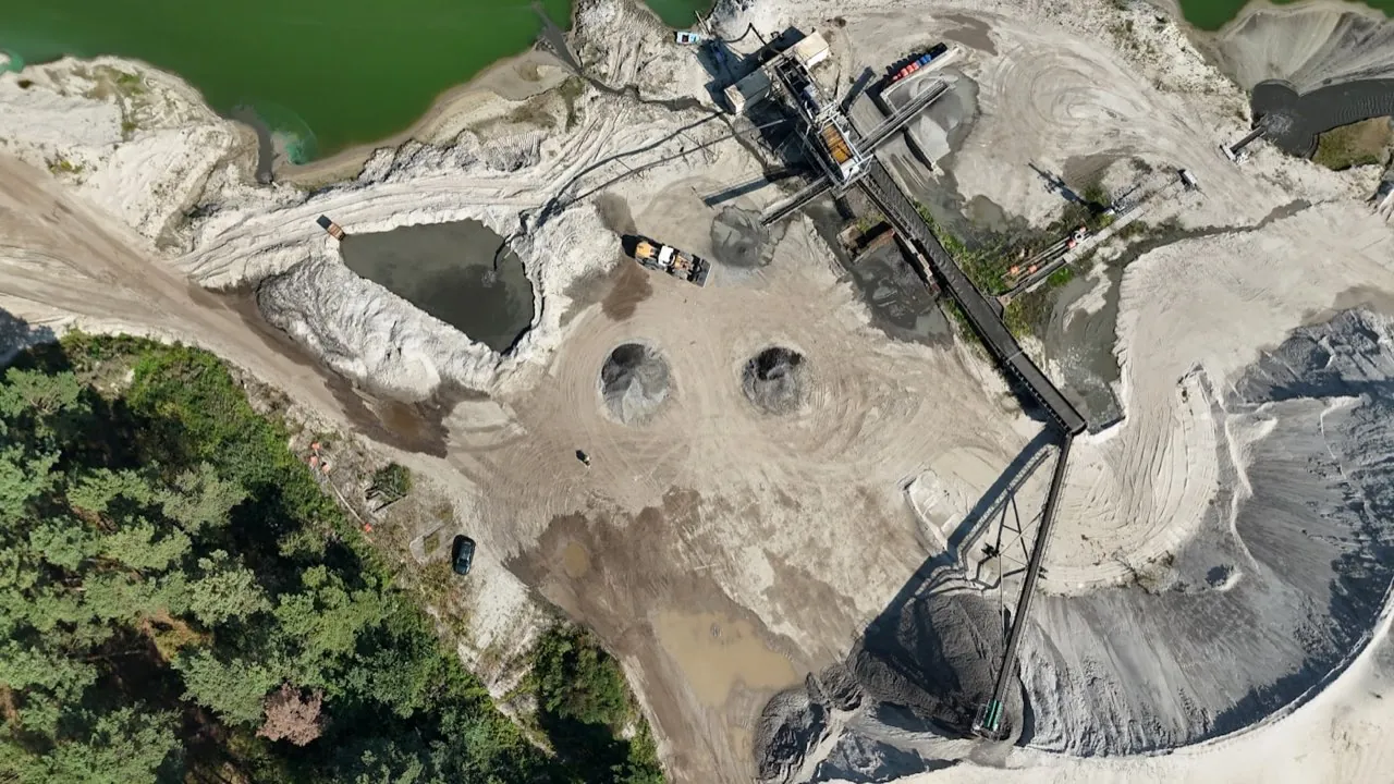
Volumetric & Earthworks Surveys Stockpile & Volume Surveys Fast, safe, and highly accurate volumetric measurements of bulk materials, aggregates, and excavations.
Typical Deliverables: Volumetric Survey Report (PDF detailing stockpile volume, area, and heights) Cut-and-Fill contour maps showing height variances 3D Mesh models of individual stockpiles for visualization CSV tables listing stockpile inventory quantities Target Accuracy: Volumetric accuracy is typically within 1% to 2% of actual volumes, far exceeding traditional cross-section methods.
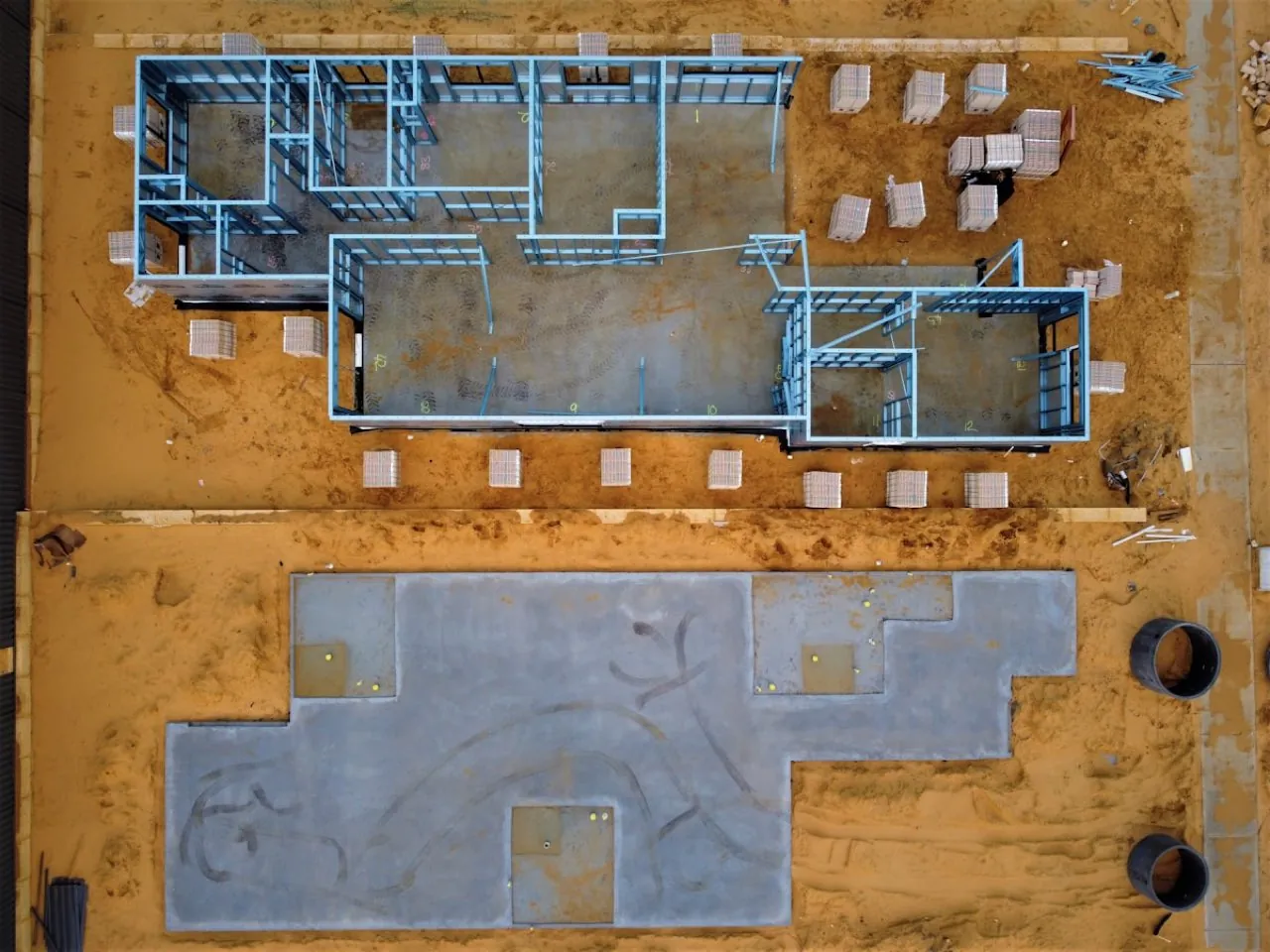
Construction & Engineering Surveys Pre-Construction Site Surveys Comprehensive baseline data capture to document existing site conditions, levels, and neighbouring assets before works begin.
Typical Deliverables: Complete 3D baseline site models and point clouds High-resolution geo-referenced site overview maps Dilapidation and structural condition photo datasets with GPS tagging CAD boundary overlays matching legal land registry plans Target Accuracy: Spatial precision of ±20mm horizontally, with high-definition imagery capturing structural cracks down to 1mm.
Building & Structure Surveys Roof Survey Data Capture High-precision measured roof surveys capturing geometry, levels, and structural profiles for dense urban properties.
Typical Deliverables: Measured 2D/3D Roof CAD Drawings (.DWG detailing slopes, heights, and equipment) High-resolution 3D Textured Mesh models of the roof structure Thermal mapping overlays to detect moisture ingress and heat loss Scale-accurate measured elevations and sectional profiles Target Accuracy: Measurement accuracy of ±15mm to ±25mm across the roof plane; visual resolution down to 1.5mm/pixel.
Residential Roof Surveys Fast, affordable drone roof inspections for homes across London — backed by a written condition report from a qualified, RICS-regulated surveyor.
Typical Deliverables: High-resolution roof imagery with geo-tagged close-up defect photographs Written roof condition report prepared by a qualified, RICS-regulated surveyor Prioritised defect schedule with practical repair recommendations Optional thermal overlay highlighting trapped moisture and heat loss Target Accuracy: High-resolution visual capture down to roughly 1–2mm per pixel, assessed and reported against a defined roof-condition defect schedule by a qualified, RICS-regulated surveyor.
Specialist Surveying LiDAR-Based UAV Surveys Advanced laser scanning from the air to penetrate dense vegetation, mapping the true ground surface with extreme precision.
Typical Deliverables: Vegetation-Penetrated Bare Earth DTMs (.TIFF / .LAS format) Classified Point Clouds (Ground, Low Veg, Medium Veg, High Veg, Buildings) Precision 3D CAD vectors of structural spans and corridor profiles Forestry canopy metrics and slope analysis reports Target Accuracy: Vertical accuracy of ±25mm to ±40mm, depending on vegetation density and terrain slopes.
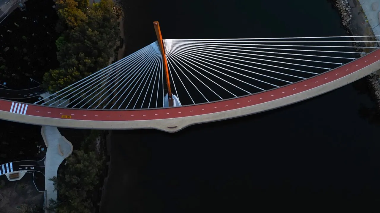
Bridge & Infrastructure Surveying Bridge Surveys Precision geometry, clearances, and structural surveys for London's historic and modern bridge crossings.
Typical Deliverables: 3D point clouds (.LAS / .LAZ) detailing bridge geometry and abutments Scale-accurate CAD drawings (.DWG) showing spans, clearances, and alignments High-resolution visual inspection logs with geo-tagged images detailing defects Geo-referenced orthomosaic mapping of the bridge deck and approaches Target Accuracy: Measurement accuracy of ±15mm to ±30mm across the visible spans, and visual defect mapping down to 1.0mm per pixel.
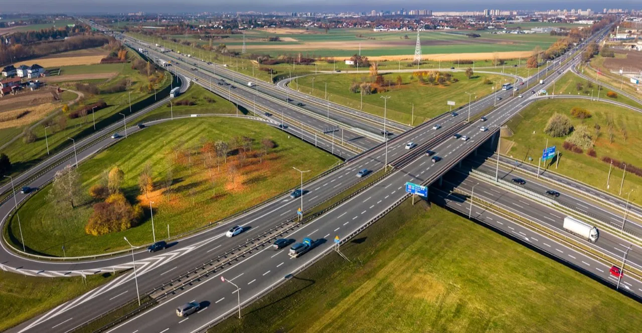
Highway & Road Surveys Measured Road Surveys High-accuracy topographic road corridor and junction surveys for highway design, resurfacing, and safety schemes across London.
Typical Deliverables: Topographic CAD files (.DWG) with detailed road markings, levels, and street furniture Digital Surface Models (DSM) and level grids at specified intervals (e.g. 1m/5m) High-resolution ortho-rectified imagery of the road corridor Detailed cross-sections and longitudinal profiles Target Accuracy: Horizontal accuracy: ±20mm; Vertical height accuracy: ±20mm to ±30mm on solid road surfaces.
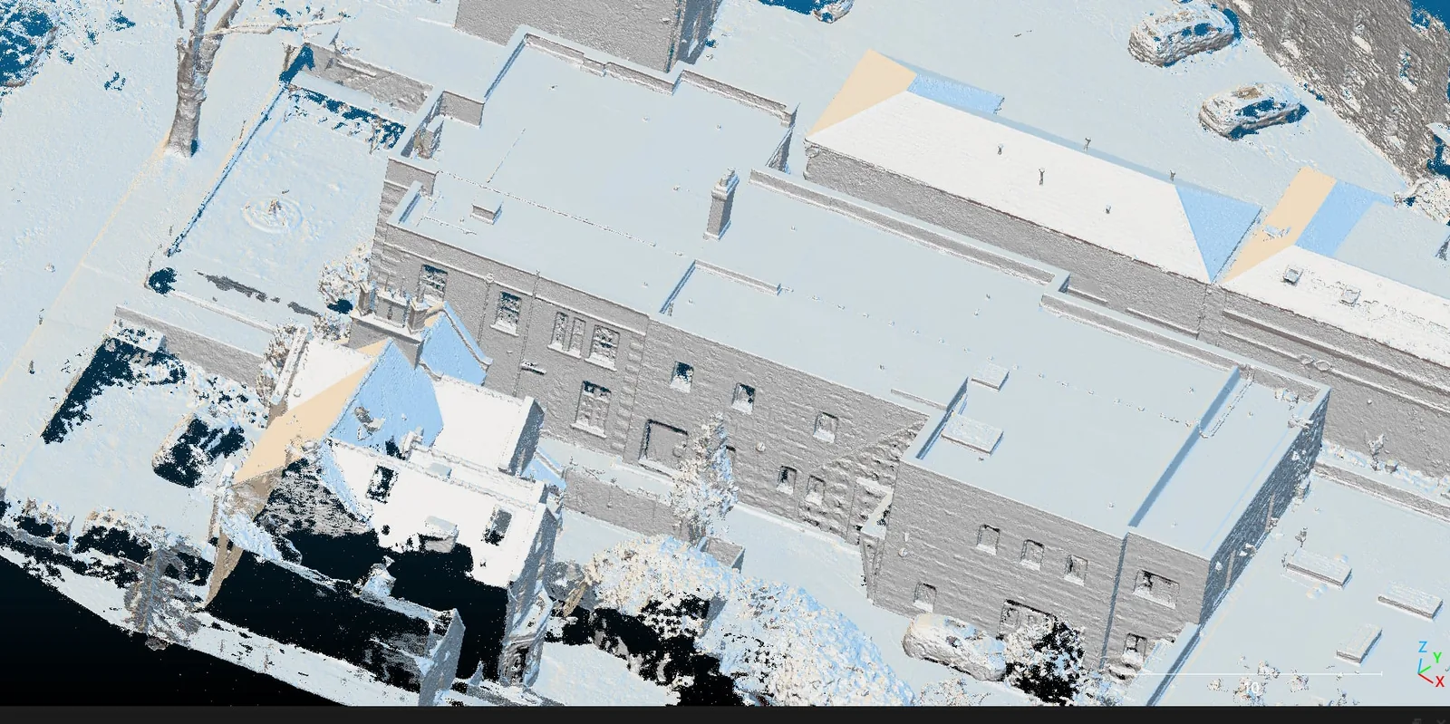
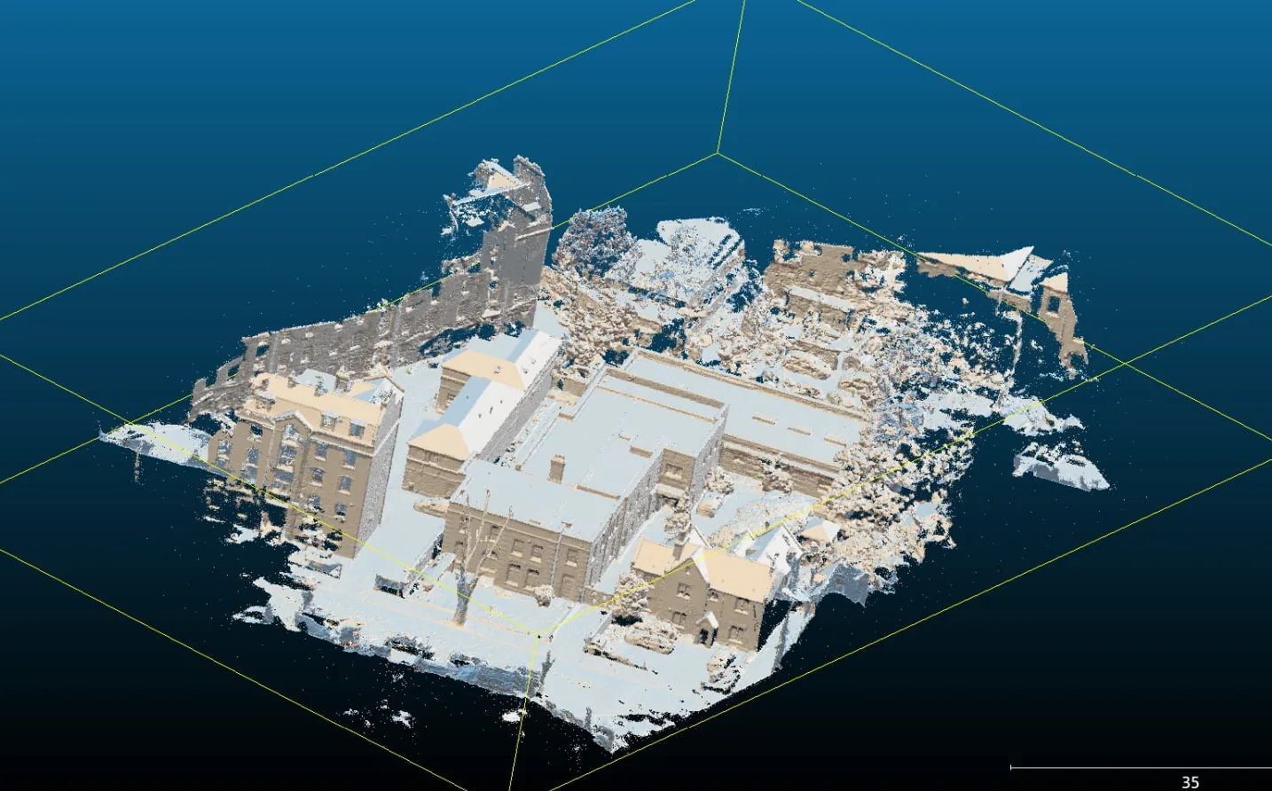
Measured Building Surveys & Laser Scanning 3D Laser Scanning Survey-grade terrestrial 3D laser scanning capturing millimetre-accurate point clouds of buildings, interiors, and structures across London.
Typical Deliverables: Registered, colourised 3D point clouds (.RCP / .E57 / .LAS) Scan-to-BIM Revit models at the specified Level of Detail (LOD 200–350) 2D measured CAD plans, elevations, and sections (.DWG) Web-hosted point cloud viewer for remote stakeholder access Target Accuracy: Registered point cloud accuracy of ±2mm to ±6mm; range noise typically under 1mm on solid surfaces.
Measured Building Surveys Accurate measured building surveys producing scaled floor plans, elevations, and sections for residential and commercial property across London.
Typical Deliverables: Scaled 2D floor plans for every level (.DWG / .DXF / PDF) Internal and external elevations and cross-sections Reflected ceiling plans and roof plans where required Site location plan tied to Ordnance Survey coordinates Target Accuracy: Drawn detail accurate to ±5mm to ±10mm, complying with survey specifications used by RICS-regulated practices.
As-Built Surveys Verification of built work against design — steelwork, structures, and services recorded and compared to model, across London.
Typical Deliverables: As-built CAD drawings and 3D models of the constructed work Deviation / tolerance reports comparing as-built to design model Registered point cloud of the constructed elements (.E57 / .RCP) Annotated verification report with pass/fail against agreed tolerances Target Accuracy: Comparison accuracy of ±3mm to ±8mm against the design model, depending on element type and access.
Matterport 3D Virtual Tours Immersive Matterport 3D virtual tours and dollhouse models for property marketing, records, and remote site walkthroughs across London.
Typical Deliverables: Hosted, shareable Matterport 3D tour with guided highlight reels 3D dollhouse and inside views with navigable walkthrough Schematic floor plan generated from the capture High-resolution still images extracted from the model Target Accuracy: Indicative in-model measurement typically within ±1% over the captured space — ideal for visualisation and space planning rather than construction-grade setting out.
Land Registry & Legal Plans Land Registry Lease Plans HM Land Registry compliant lease plans with accurate red-line demise, prepared to the correct scale for leasehold registration across London.
Typical Deliverables: HM Land Registry compliant lease plan (PDF, ready to attach to the lease) Red-edged demise with parking, storage, and shared areas identified Scaled floor plans for each demised level with scale bar and north point Editable CAD source file (.DWG) for future amendments Target Accuracy: Drawn to a recognised metric scale (1:100 / 1:200 / 1:500) with measured detail to ±10mm, meeting HM Land Registry plan requirements.
Land Registry Title Plans Accurate, compliant title plans defining property and land boundaries for first registration, transfers, and boundary clarification across London.
Typical Deliverables: HM Land Registry compliant title plan (PDF for submission) Defined boundary edged to Land Registry convention with measurements Annotation of easements, rights of way, and excluded land where required Editable CAD source file (.DWG) for transfers and future plot splits Target Accuracy: Drawn on Ordnance Survey base to a recognised metric scale; measured boundary detail to ±10mm where a site survey is undertaken.
MEP Design & BIM MEP Design & BIM Coordination Coordinated mechanical, electrical, and plumbing design with clash-free BIM modelling for building and refurbishment projects across London.
Typical Deliverables: Coordinated MEP Revit/BIM model at the agreed Level of Detail 2D design and installation drawings for each service (.DWG / PDF) Clash detection report (Navisworks) with resolved conflicts logged Builders' work and penetration drawings for structural coordination Target Accuracy: Coordination modelled to the project BIM Execution Plan (typically LOD 300–350), built on survey data accurate to a few millimetres.
Marine & Hydrographic Surveys Marine & Hydrographic Surveys Specialist surveys of vessels, pontoons, sea walls, moorings, and riverbeds — combining above-water capture with hydrographic measurement across London's waterways.
Typical Deliverables: Bathymetric / riverbed depth models and contours referenced to Chart Datum Above-water 3D point clouds and CAD of vessels, pontoons, and river walls Condition and clearance reports for marine structures Combined above- and below-water sections and plans (.DWG) Target Accuracy: Above-water capture to ±10mm to ±30mm; hydrographic depths referenced to Chart Datum within survey-grade tidal tolerances.
Need a Bespoke Geospatial Survey? We work closely with structural engineers, CAD managers, and BIM coordinators to deliver custom coordinate projections and custom file formats. Contact our team to discuss your project requirements.